575
Captain
There is no Purgatory for warcriminals - they go directly to Hell!
Posts: 2,729 
Likes: 4,106
|
Post by 575 on Apr 29, 2022 21:14:48 GMT
Or instead of language - either way interesting.
|
|
lordroel
Administrator
Posts: 67,964 
Likes: 49,365
|
Post by lordroel on Apr 30, 2022 14:02:18 GMT
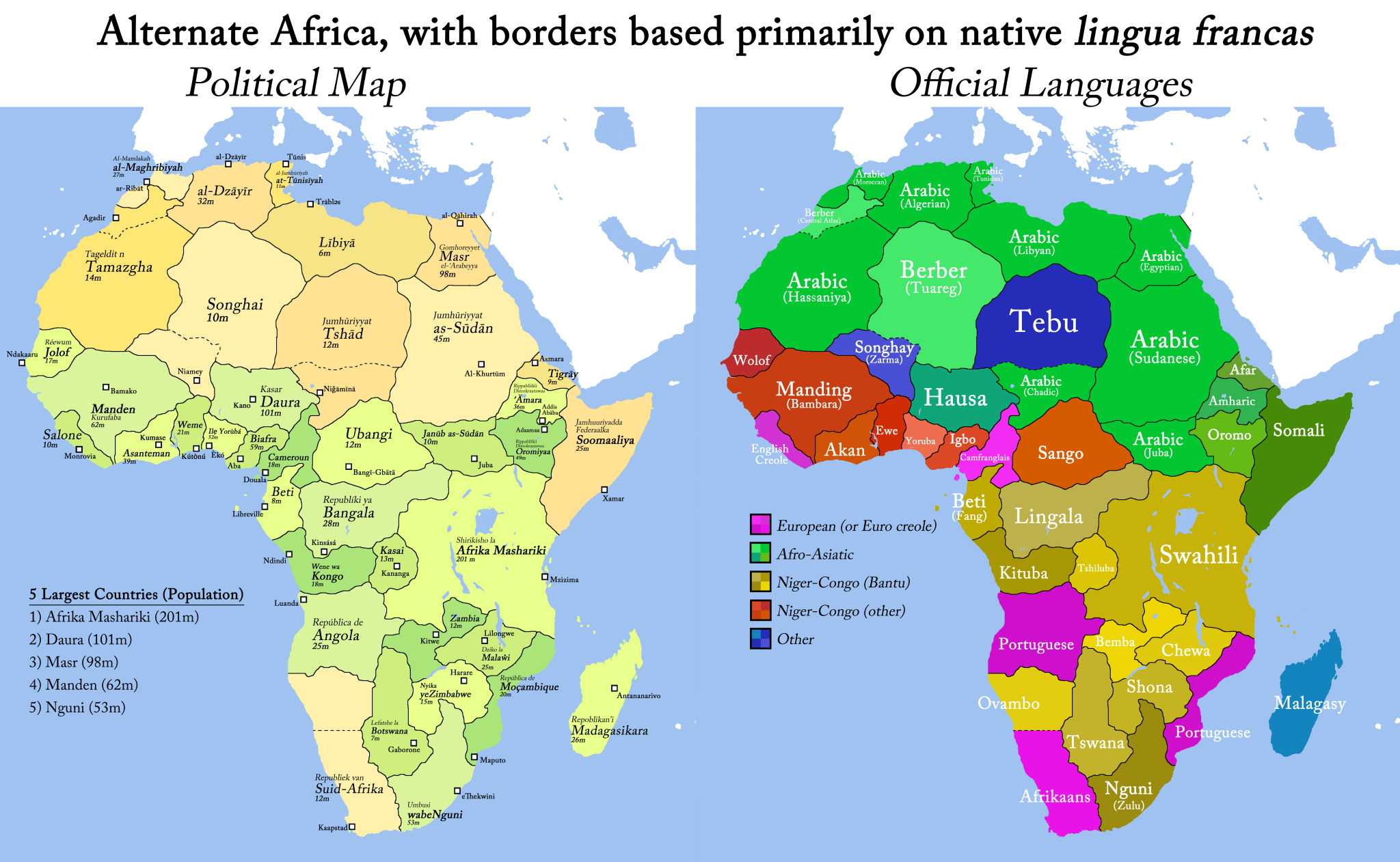
Or instead of language - either way interesting. Well here is one based on language. Hypothetical Africa, with borders based primarily on indigenous lingua francas.  |
|
stevep
Fleet admiral
Posts: 24,832 
Likes: 13,222
|
Post by stevep on Apr 30, 2022 15:38:45 GMT
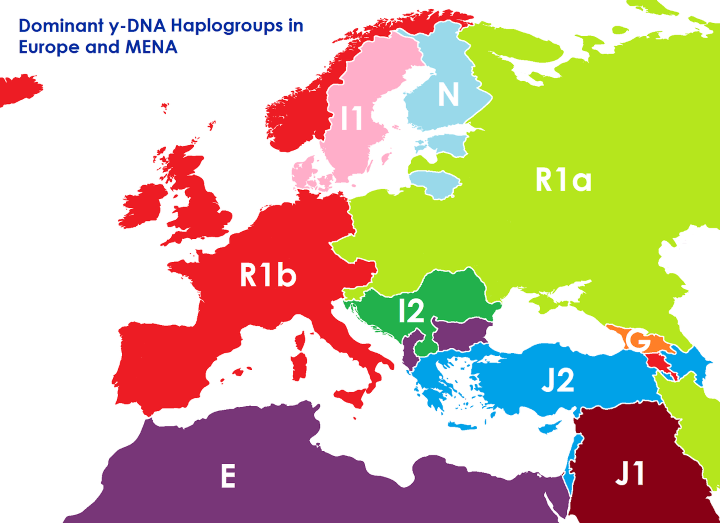
Interesting that Sweden and Denmark are separate from the rest of the 'Germanic' world. Also that Lithuania is closer to Finland and Estonia than anywhere else. The distribution of the J2 group would seem to suggest that Greeks and Turks are a lot closer than either would like to think. Plus that Israel is also in the same group?
|
|
575
Captain
There is no Purgatory for warcriminals - they go directly to Hell!
Posts: 2,729 
Likes: 4,106
|
Post by 575 on Apr 30, 2022 18:12:10 GMT
Interesting that Sweden and Denmark are separate from the rest of the 'Germanic' world. Also that Lithuania is closer to Finland and Estonia than anywhere else. The distribution of the J2 group would seem to suggest that Greeks and Turks are a lot closer than either would like to think. Plus that Israel is also in the same group?
Yes along Lebanon, Cyprus and Azerbajdjan.
Danish and Swedish are East Nordic dialect; Norwegian West Nordic along Faeroe Is and Iceland.
|
|
lordroel
Administrator
Posts: 67,964 
Likes: 49,365
|
Post by lordroel on May 11, 2022 16:18:47 GMT
|
|
mspence
Warrant Officer
Posts: 281 
Likes: 243
|
Post by mspence on Aug 13, 2023 6:10:24 GMT
So I found this:  Needless to say, I agree that Philip K. Dick might have seen it... |
|
mspence
Warrant Officer
Posts: 281 
Likes: 243
|
Post by mspence on Aug 13, 2023 6:15:07 GMT
|
|
stevep
Fleet admiral
Posts: 24,832 
Likes: 13,222
|
Post by stevep on Aug 13, 2023 11:40:14 GMT
So I found this:  Needless to say, I agree that Philip K. Dick might have seen it...
My old eyes can't make out the details but judging by the colour scheme this is after a successful Anglo-Japanese 'liberation' of much of the US's coastal regions, plus a demilitarised zone [in blue] and Canada and Mexico also getting their share [green and tan].
Its a strange into because the mention of losses by Germany and Austria of their best lands [which wasn't really the case for Germany] suggests a comparison with Versailles in 1919 - which would also fit in with a war with an AJA but Poland actually gained from that conflict in that it became independent after over a century of being occupied by three neighbours.
In reality assuming that the US was involved in and lost such a war - which would be difficult in the early 1920's when the AJA was still in place given how strained Britain was - its unlikely there would be such large scale occupation simply because of the burden of maintaining control - unless the war was very nasty and/or the US government involved really alienated a lot of the people in the occupied zones.
I have the feeling I've seen this map before but whether it was here or elsewhere I don't know.
Sorry, scrap all that. Finally noticed the link and seen its actually from the late 30's. probably even more unrealistic then. the Red colour on the east coast and the fact there were a couple of areas I had taken as buffer areas for Canada mislead me. Apologies about that.  |
|
lordroel
Administrator
Posts: 67,964 
Likes: 49,365
|
Post by lordroel on Aug 13, 2023 11:45:00 GMT
So I found this:  Needless to say, I agree that Philip K. Dick might have seen it... My old eyes can't make out the details but judging by the colour scheme this is after a successful Anglo-Japanese 'liberation' of much of the US's coastal regions, plus a demilitarised zone [in blue] and Canada and Mexico also getting their share [green and tan]. Its a strange into because the mention of losses by Germany and Austria of their best lands [which wasn't really the case for Germany] suggests a comparison with Versailles in 1919 - which would also fit in with a war with an AJA but Poland actually gained from that conflict in that it became independent after over a century of being occupied by three neighbours. In reality assuming that the US was involved in and lost such a war - which would be difficult in the early 1920's when the AJA was still in place given how strained Britain was - its unlikely there would be such large scale occupation simply because of the burden of maintaining control - unless the war was very nasty and/or the US government involved really alienated a lot of the people in the occupied zones. I have the feeling I've seen this map before but whether it was here or elsewhere I don't know.
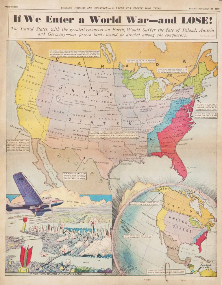
4 years ago in this thread stevep , you had the same eye problem: Map: If We Enter A World War - And Lost (Hypothetical invasion America) in 1937So posted the text that you can see: The text of the Blue area is: The "CORRIDOR of DEATH" where America bounty of Steel, Coal and Cotton could be diverted to channels of destruction. Munitions plants dwarfing the combined output of all Europe would spring up in this "buffer state," cut out of the heart of a continent that was Poland.
The text of the Red area is: The rich East Coast would be stripped from the U.S. and divided among foreign powers.The text of the New York area is: New York City, to rich a prize to be awarded to a single conqueror, would be a international free port.The text of the Green area is: The Empire State corridor conceded to the U.S. as a buffer between two victorious allies who may be enemies in the next conflict.The text of what remain of the United States area is: All that is left of the United States of america - reduced by pressure of embattled conquerors on all sides. " we could still till our soil, man our industries and conduct our business affairs, we could ship products abroad- under supervision and control of other powers.
The text of the Yellow area is: Our Rich Pacific Coast. With a wealth of minerals, oil, lumber and its most natural advantages would fall east pray to the allied conquerors. This Empire could be defended against attack from the East.The text of the Brown area is:
As a reward to one of the successful allies, this section, rich in farming and mineral resources would be ceded. |
|
stevep
Fleet admiral
Posts: 24,832 
Likes: 13,222
|
Post by stevep on Aug 13, 2023 11:51:41 GMT
My old eyes can't make out the details but judging by the colour scheme this is after a successful Anglo-Japanese 'liberation' of much of the US's coastal regions, plus a demilitarised zone [in blue] and Canada and Mexico also getting their share [green and tan]. Its a strange into because the mention of losses by Germany and Austria of their best lands [which wasn't really the case for Germany] suggests a comparison with Versailles in 1919 - which would also fit in with a war with an AJA but Poland actually gained from that conflict in that it became independent after over a century of being occupied by three neighbours. In reality assuming that the US was involved in and lost such a war - which would be difficult in the early 1920's when the AJA was still in place given how strained Britain was - its unlikely there would be such large scale occupation simply because of the burden of maintaining control - unless the war was very nasty and/or the US government involved really alienated a lot of the people in the occupied zones. I have the feeling I've seen this map before but whether it was here or elsewhere I don't know.
4 years ago in this thread stevep , you had the same eye problem: Map: If We Enter A World War - And Lost (Hypothetical invasion America) in 1937So posted the text that you can see: The text of the Blue area is: The "CORRIDOR of DEATH" where America bounty of Steel, Coal and Cotton could be diverted to channels of destruction. Munitions plants dwarfing the combined output of all Europe would spring up in this "buffer state," cut out of the heart of a continent that was Poland.
The text of the Red area is: The rich East Coast would be stripped from the U.S. and divided among foreign powers.The text of the New York area is: New York City, to rich a prize to be awarded to a single conqueror, would be a international free port.The text of the Green area is: The Empire State corridor conceded to the U.S. as a buffer between two victorious allies who may be enemies in the next conflict.The text of what remain of the United States area is: All that is left of the United States of america - reduced by pressure of embattled conquerors on all sides. " we could still till our soil, man our industries and conduct our business affairs, we could ship products abroad- under supervision and control of other powers.
The text of the Yellow area is: Our Rich Pacific Coast. With a wealth of minerals, oil, lumber and its most natural advantages would fall east pray to the allied conquerors. This Empire could be defended against attack from the East.The text of the Brown area is:
As a reward to one of the successful allies, this section, rich in farming and mineral resources would be ceded.
An well you nijied me with a quick response. Sorry about that as I realized when I saw the link that it was based on a war with the fascist powers. [Although why they painted a large part of the east coast red I don't know?
|
|
lordroel
Administrator
Posts: 67,964 
Likes: 49,365
|
Post by lordroel on Aug 13, 2023 11:54:46 GMT
4 years ago in this thread stevep , you had the same eye problem: Map: If We Enter A World War - And Lost (Hypothetical invasion America) in 1937So posted the text that you can see: The text of the Blue area is: The "CORRIDOR of DEATH" where America bounty of Steel, Coal and Cotton could be diverted to channels of destruction. Munitions plants dwarfing the combined output of all Europe would spring up in this "buffer state," cut out of the heart of a continent that was Poland.
The text of the Red area is: The rich East Coast would be stripped from the U.S. and divided among foreign powers.The text of the New York area is: New York City, to rich a prize to be awarded to a single conqueror, would be a international free port.The text of the Green area is: The Empire State corridor conceded to the U.S. as a buffer between two victorious allies who may be enemies in the next conflict.The text of what remain of the United States area is: All that is left of the United States of america - reduced by pressure of embattled conquerors on all sides. " we could still till our soil, man our industries and conduct our business affairs, we could ship products abroad- under supervision and control of other powers.
The text of the Yellow area is: Our Rich Pacific Coast. With a wealth of minerals, oil, lumber and its most natural advantages would fall east pray to the allied conquerors. This Empire could be defended against attack from the East.The text of the Brown area is:
As a reward to one of the successful allies, this section, rich in farming and mineral resources would be ceded. An well you nijied me with a quick response. Sorry about that as I realized when I saw the link that it was based on a war with the fascist powers. [Although why they painted a large part of the east coast red I don't know?
The Red Area is almost the size of the former 13 Colonies, guess who will get them. |
|
stevep
Fleet admiral
Posts: 24,832 
Likes: 13,222
|
Post by stevep on Aug 13, 2023 17:27:52 GMT
An well you nijied me with a quick response. Sorry about that as I realized when I saw the link that it was based on a war with the fascist powers. [Although why they painted a large part of the east coast red I don't know?
The Red Area is almost the size of the former 13 Colonies, guess who will get them.
Well I was wondering whether some particularly Anglo-phobic elements were behind the image, although it does leave out most of the northern colonies. Let alone the unsettled territories of the 13 colonies prior to 1783. That's the only reason why I can think their picking the colour red.
|
|
lordroel
Administrator
Posts: 67,964 
Likes: 49,365
|
Post by lordroel on Aug 13, 2023 17:35:26 GMT
The Red Area is almost the size of the former 13 Colonies, guess who will get them. Well I was wondering whether some particularly Anglo-phobic elements were behind the image, although it does leave out most of the northern colonies. Let alone the unsettled territories of the 13 colonies prior to 1783. That's the only reason why I can think their picking the colour red.
And Yellow is of course for Japan who we now in may Axis invade America always get the Pacific states. |
|
autochrome
Petty Officer 2nd Class
Posts: 33
Likes: 51
|
Post by autochrome on Aug 14, 2023 12:06:32 GMT
I wonder why every crazy United States-gets-divided scenario has Japan taking the West Coast. The WWI ones also have them do this, even though they were also on the Entente.
|
|
lordroel
Administrator
Posts: 67,964 
Likes: 49,365
|
Post by lordroel on Aug 14, 2023 13:05:42 GMT
I wonder why every crazy United States-gets-divided scenario has Japan taking the West Coast. The WWI ones also have them do this, even though they were also on the Entente. Who else, China. |
|


