lordroel
Administrator
Posts: 67,964 
Likes: 49,365
|
Post by lordroel on Oct 8, 2015 17:05:39 GMT
Internet has a nice collection of alternate history maps based on series, books, movies, anime comics and a lot more, here are some of them. First the map from The Man in the High Castle TV series. The Man in the High Castle (TV Series) map.  The former United States of America divided into three parts: the Japanese Pacific States in the west, the Greater Nazi Reich in the east (erroneously labeled as "Great Nazi Reich") and the Rocky Mountain States (or the Neutral Zone). |
|
lordroel
Administrator
Posts: 67,964 
Likes: 49,365
|
Post by lordroel on Oct 10, 2015 11:36:09 GMT
Bring the JubileeA alternate history novel written by Ward Moore in 1953. The point of divergence occurs in July 1863 when the Confederate States of America wins the Battle of Gettysburg and subsequently declares victory in the "War of Southern Independence" on July 4, 1864, after the surrender of the United States of America. The novel takes place in the impoverished rump United States in the mid-20th century as war looms between the Confederacy and its rival, the German Union. History takes an unexpected turn when the protagonist Hodge Backmaker, a historian, decides to travel back in time to witness the moment when the South won the war 
|
|
lordroel
Administrator
Posts: 67,964 
Likes: 49,365
|
Post by lordroel on Oct 12, 2015 17:10:54 GMT
Fatherland (novel)
|
|
lordroel
Administrator
Posts: 67,964 
Likes: 49,365
|
Post by lordroel on Oct 13, 2015 15:04:21 GMT
The Domination of Draka (novel series)The Draka world in 1942. 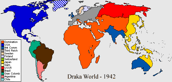 The Draka world in 1948. 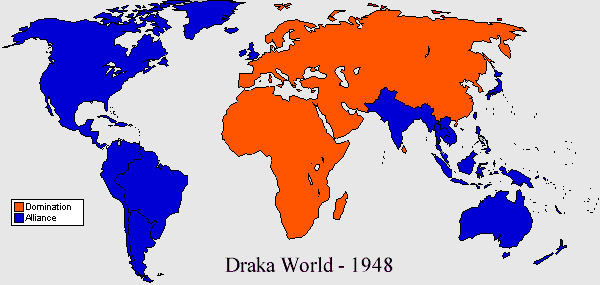
|
|
lordroel
Administrator
Posts: 67,964 
Likes: 49,365
|
Post by lordroel on Oct 16, 2015 10:04:12 GMT
Crimson Skies (computer game)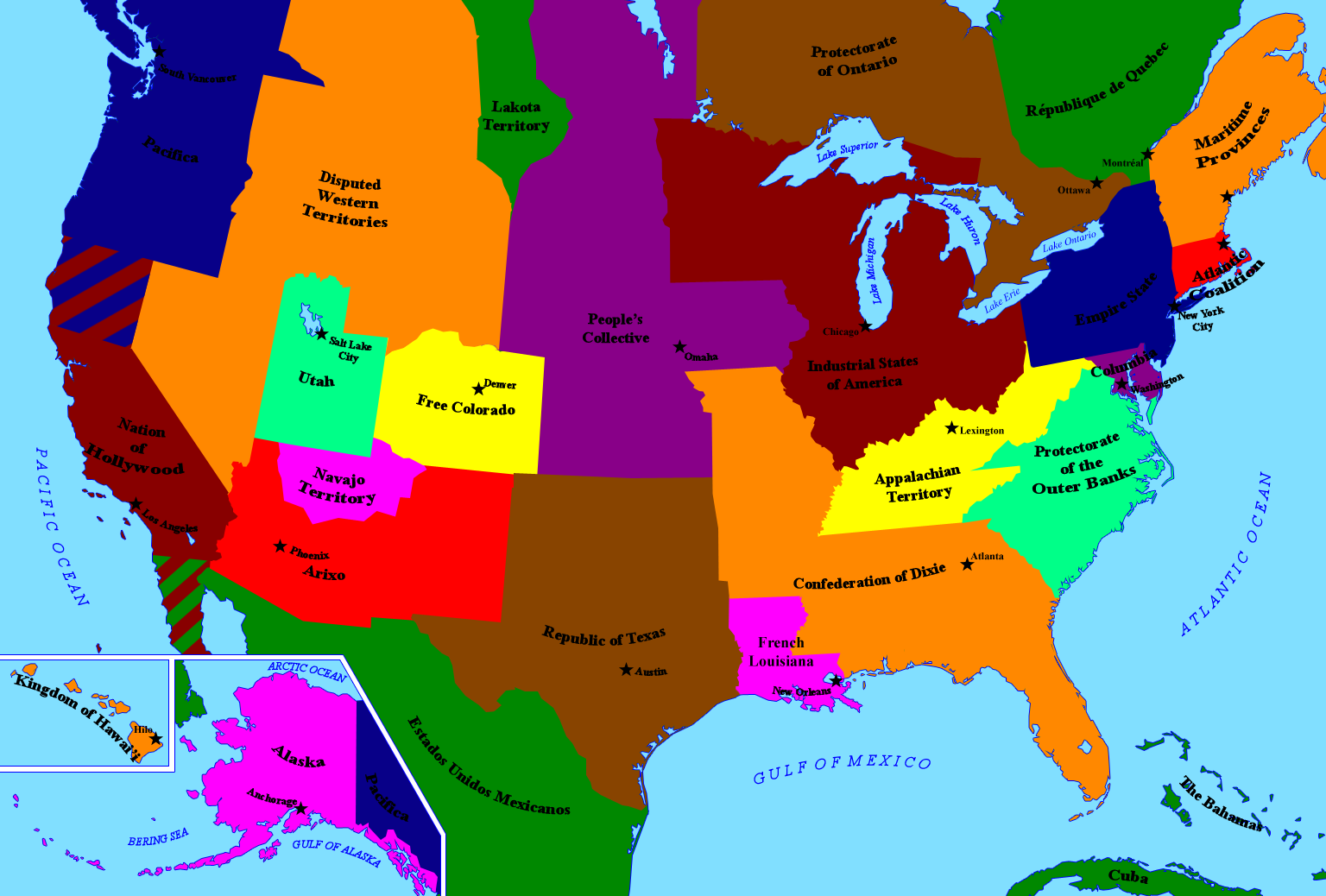
|
|
lordroel
Administrator
Posts: 67,964 
Likes: 49,365
|
Post by lordroel on Oct 17, 2015 9:42:06 GMT
Ghost in the Shell (anime)
|
|
lordroel
Administrator
Posts: 67,964 
Likes: 49,365
|
Post by lordroel on Oct 19, 2015 2:31:18 GMT
In the Presence of Mine Enemies (novel)
|
|
lordroel
Administrator
Posts: 67,964 
Likes: 49,365
|
Post by lordroel on Oct 21, 2015 3:09:24 GMT
Southern Victory series or Timeline-191 (novels) World Map showing the participants in "Great War II". The "Entente" (sometimes referred to as "The Allies") are depicted in green, the "Central Powers" in orange, and neutral countries in grey.
|
|
lordroel
Administrator
Posts: 67,964 
Likes: 49,365
|
Post by lordroel on Oct 22, 2015 14:05:40 GMT
Old map of North America based on Robert Sobel\'s alternate history novel For Want of a Nail, 1870.
|
|
lordroel
Administrator
Posts: 67,964 
Likes: 49,365
|
Post by lordroel on Oct 28, 2015 15:51:51 GMT
Nineteen Eighty-Four, 1984 (Novel)
|
|
lordroel
Administrator
Posts: 67,964 
Likes: 49,365
|
Post by lordroel on Oct 29, 2015 16:27:45 GMT
WorldWar series (novels) (Red) United States of America. (Blue) Race controlled territory. (Green) Empire of japan. (Black) Third Reich. (Orange) Soviet Union. (Purple) United Kingdom.
|
|
lordroel
Administrator
Posts: 67,964 
Likes: 49,365
|
Post by lordroel on Oct 30, 2015 9:28:49 GMT
The Peshawar Lancers (Novel)
|
|
lordroel
Administrator
Posts: 67,964 
Likes: 49,365
|
Post by lordroel on Nov 4, 2015 16:27:41 GMT
Jericho (TV series) (Red) Allied States of America. (Blue) United States of America. (Purple) the independent Republic of Texas.
|
|
lordroel
Administrator
Posts: 67,964 
Likes: 49,365
|
Post by lordroel on Nov 8, 2015 9:18:12 GMT
Fringe (TV series)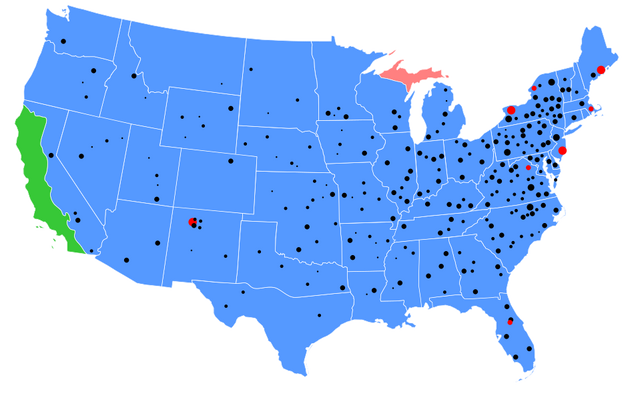 A depiction of the United States as seen on the wall of Secretary Bishop's office at the Department of Defense in the alternate universe. Differences include:the western part of California (green) is part of Mexico or is part of another continent resulting from when Pangea broke up (or possibly sank into the sea) The northern peninsula of Michigan is part of Canada (purple). Texas was split into North Texas and South Texas. The Dakota Territory was never split into North Dakota and South Dakota. The Oklahoma Territory and the Kansas Territory were unified into one state called "Midland". West Virginia never seceded from Virginia (or was re-unified). The Province of Carolina was never split into North Carolina and South Carolina. The black dots represent "fringe" incidents. The red dots indicate quarantined areas. Other differences not depicted on this map;Louisiana is called "Louisiana Territory". Nevada is called "Independent Nevada". The area around Washington, D.C., is called the "District of Virginia" instead. The state of Washington is called "Southern British Columbia"
|
|
lordroel
Administrator
Posts: 67,964 
Likes: 49,365
|
Post by lordroel on Nov 9, 2015 4:17:33 GMT
The Two Georges (novel)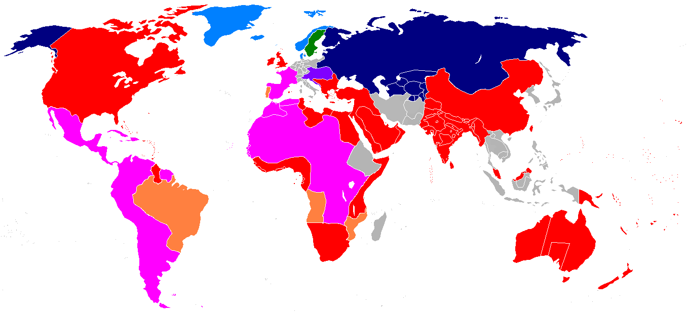 Map of the world in The Two Georges. The British Empire, its protectorates and dominions are denoted in red; pink is the territory of the Franco-Spanish "Holy Alliance"; orange is Portuguese territory; purple is the Austrian Empire; green is Sweden; light blue is the Danish Empire and dark blue is the Russian Empire. Ownership and political organization of grey areas is unclear.
|
|


