lordroel
Administrator
Member is Online
Posts: 67,964 
Likes: 49,369
|
Post by lordroel on Dec 25, 2015 14:52:23 GMT
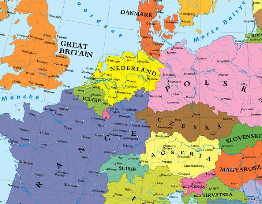
Germany carved amongst her neighbors Hanover part of the Netherlands, Kassel ruled by France, Nuremberg part of a Bohemia that reaches to the Frankfurt suburbs, Hamburg in Denmark, Regensburg on the Austro-Czech border. This map comes from an article from Die Zeit and shows a map of a Europe without a Germany. Now you thing this is pure ASB, but it is not, there were plans of one sort or another to achieve similar results at the end of the Second World War. The major plan for the dissection of Germany was merely a creation of Nazi propaganda, and while the vaguely similar Morgenthau Plan did exist, it was soon shelved once its impracticality became obvious. Morgenthau Plan (Large Danube federation)

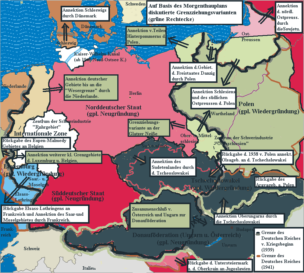
Another variant of the Morgenthau Plan: a North German State, South German State and large Danube Federation (Austria, Hungary and Czechoslovakia) plus annexation of German border areas by the Netherlands (Dutch annexation of German territory after World War II), Denmark (Schleswig), Poland, USSR, Luxembourg, Belgium and France) Bakker-Schut PlanThe Bakker-Schut Plan, meanwhile, was a Netherlands proposal for the annexation of several German towns, and perhaps even a number of German cities. German natives would be expelled, except for those who spoke the Low Franconian dialect, who would be forcibly dutchified. They even came up with a list of new Dutch names for German cities. Map of the Bakker-Schut PlanThe Bakker-Schut Plan. To the left is the Netherlands, to the right is the part of Germany known as Lower Saxony and North Rhine-Westphalia. The coloured areas in the middle are the parts proposed for annexation by the Netherlands. 
|
|
futurist
Banned
Banned
Posts: 837 
Likes: 12
|
Post by futurist on Jun 19, 2016 2:05:14 GMT
Morgenthau Plan (Large Danube federation)
 For the record, Germany's planned territorial losses in the East in this scenario were actually smaller than Germany's territorial losses in the East in real life!  |
|
spanishspy
Fleet admiral
Posts: 10,366 
Likes: 1,587
|
Post by spanishspy on Jun 19, 2016 4:46:46 GMT
I heard that the successful implementation of the Morgenthau Plan would have caused mass starvation and death, a la the Great Leap Forward.
It's for the best that didn't happen.
|
|
stevep
Fleet admiral
Posts: 24,832 
Likes: 13,222
|
Post by stevep on Jun 19, 2016 11:39:13 GMT
I heard that the successful implementation of the Morgenthau Plan would have caused mass starvation and death, a la the Great Leap Forward. It's for the best that didn't happen. From what I understand, because it involved the forced de-industrialisation of Germany, making it largely an agricultural state, a high death rate, or at least massed forced emigration [although to where I don't know?] would have been likely. It would also have really screwed the economy of Europe as a whole and its difficult to see it lasting for long even if an attempt was made to implement it. |
|
spanishspy
Fleet admiral
Posts: 10,366 
Likes: 1,587
|
Post by spanishspy on Jun 19, 2016 18:15:38 GMT
I heard that the successful implementation of the Morgenthau Plan would have caused mass starvation and death, a la the Great Leap Forward. It's for the best that didn't happen. From what I understand, because it involved the forced de-industrialisation of Germany, making it largely an agricultural state, a high death rate, or at least massed forced emigration [although to where I don't know?] would have been likely. It would also have really screwed the economy of Europe as a whole and its difficult to see it lasting for long even if an attempt was made to implement it. Ironically it may provide another chance for Fascism to take root. There would be terrorists a la the Red Army Faction but right wing. |
|
lordroel
Administrator
Member is Online
Posts: 67,964 
Likes: 49,369
|
Post by lordroel on Jun 21, 2016 15:21:29 GMT
Here is another map, this one was put on a postcard which depicts a future Without Germany, Circa 1914.  - From the north, Denmark reaches deep down all the way to Magdebourg, along the way annexing Hambourg, Brème and Lunebourg (to add insult to injury, all cities on the map are represented in their French spelling). - Denmark gets a new neighbor: Imperial Russia, her westward thrust halting only at the Elbe, henceforth marking the Danish-Russian border. Berlin, Dresden, Torgau and other ancient German cities now owe allegiance to the Tsar rather than the Kaiser. - In 1913, Austria was still an empire in its own right. Rather than collapsing after the war, as it did in real life, it retains Bohemia (part of independent Czechoslovakia after 1918) and gains Bavaria, adding fabled cities such as Munich, Nuremberg and Schweinfurt to its holdings. - The Austrian emperor also gains a new neighbor – France. The French move up the Rhine all the way to Cologne, and cross the river as far east as Würzburg, also annexing Freiburg, Stuttgart and Frankfurt. - Even plucky little Belgium gets part of the spoils: a curious, northeastern tail of territory, just east of the Dutch Limburg salient and mirroring its southward jut. Nothing for the Dutch, though. The Franco-Anglo-Russian conspiracy accurately foresaw that the Netherlands would sit this conflict out. |
|
stevep
Fleet admiral
Posts: 24,832 
Likes: 13,222
|
Post by stevep on Jun 21, 2016 16:09:48 GMT
I'm guessing that this was a German propaganda postcard? Also that since it includes Belgium as having part of the 'spoils' it was published after the German invasion of Belgium.
|
|
lordroel
Administrator
Member is Online
Posts: 67,964 
Likes: 49,369
|
Post by lordroel on Jun 21, 2016 16:20:57 GMT
I'm guessing that this was a German propaganda postcard? Also that since it includes Belgium as having part of the 'spoils' it was published after the German invasion of Belgium. I think you are right, a classic look what our enemy will do to us map. |
|
spanishspy
Fleet admiral
Posts: 10,366 
Likes: 1,587
|
Post by spanishspy on Jun 21, 2016 16:41:37 GMT
I'm guessing that this was a German propaganda postcard? Also that since it includes Belgium as having part of the 'spoils' it was published after the German invasion of Belgium. I think you are right, a classic look what our enemy will do to us map. But then why is the heading in French? |
|
lordroel
Administrator
Member is Online
Posts: 67,964 
Likes: 49,369
|
Post by lordroel on Jun 21, 2016 17:08:20 GMT
I think you are right, a classic look what our enemy will do to us map. But then why is the heading in French? The postcard originally comes from a French book, published in 1913 in Paris. Its title: Le partage de l'Allemagne – L'échéance de demain (The Division of Germany – Our Goal for Tomorrow) but the fun thing is the Germans in 1914 used it as a propaganda postcard using the enemy (the French) own creation. The German translation at the bottom is: How the French, English and Russians divided our Germany even before the Declaration of War. |
|
spanishspy
Fleet admiral
Posts: 10,366 
Likes: 1,587
|
Post by spanishspy on Jun 21, 2016 17:12:55 GMT
But then why is the heading in French? The postcard originally comes from a French book, published in 1913 in Paris. Its title: Le partage de l'Allemagne – L'échéance de demain (The Division of Germany – Our Goal for Tomorrow) but the fun thing is the Germans in 1914 used it as a propaganda postcard using the enemy (the French) own creation. The German translation at the bottom is: How the French, English and Russians divided our Germany even before the Declaration of War. Clever of the Germans, then. |
|
lordroel
Administrator
Member is Online
Posts: 67,964 
Likes: 49,369
|
Post by lordroel on Jun 21, 2016 17:25:36 GMT
The postcard originally comes from a French book, published in 1913 in Paris. Its title: Le partage de l'Allemagne – L'échéance de demain (The Division of Germany – Our Goal for Tomorrow) but the fun thing is the Germans in 1914 used it as a propaganda postcard using the enemy (the French) own creation. The German translation at the bottom is: How the French, English and Russians divided our Germany even before the Declaration of War. Clever of the Germans, then. Yes they are, they can show their people, he, this is what the French want to do with our beautiful and peaceful country. |
|
spanishspy
Fleet admiral
Posts: 10,366 
Likes: 1,587
|
Post by spanishspy on Jun 22, 2016 13:05:17 GMT
Clever of the Germans, then. Yes they are, they can show their people, he, this is what the French want to do with our beautiful and peaceful country. Certainly an intelligent move, using the enemy's words against them. |
|
futurist
Banned
Banned
Posts: 837 
Likes: 12
|
Post by futurist on Jun 23, 2016 0:51:52 GMT
Here is another map, this one was put on a postcard which depicts a future Without Germany, Circa 1914.  Frankly, if one ignores Czechia, this map actually does a relatively good job of "predicting" the extent of the advance of the Russian/Red Army in 1945--three decades after this map was made. |
|
spanishspy
Fleet admiral
Posts: 10,366 
Likes: 1,587
|
Post by spanishspy on Jun 23, 2016 2:08:09 GMT
Here is another map, this one was put on a postcard which depicts a future Without Germany, Circa 1914.  Frankly, if one ignores Czechia, this map actually does a relatively good job of "predicting" the extent of the advance of the Russian/Red Army in 1945--three decades after this map was made. I can certainly see it, although East Germany got more of Thuringia. |
|


