lordroel
Administrator
Posts: 67,964 
Likes: 49,369
|
Post by lordroel on Nov 11, 2016 13:49:14 GMT
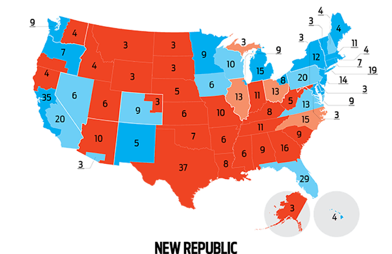
Map: elections with state secession states
 The electoral map divides the country neatly into blue states and red states. But blue states include vast conservative stretches; and most red states harbor liberal enclaves, too. In recent years, as partisan polarization has grown, some political minorities in these disaffected areas have proposed a radical solution: state partition. It has happened before. Maine, for instance, was once part of Massachusetts. And while none of the current movements really has a shot, the eleven instances mapped here (including that to grant the District of Columbia statehood) have at least attracted the support of elected officials. What would happen if all of them succeeded? Each new state would get two senators and its share of electoral college votes. New states:
Baja Arizona, electoral votes: 3. Chicago, electoral votes: 9. Jefferson, electoral votes: 4. Northeast Ohio, electoral votes: 8. South California, electoral votes: 20. Upstate New York, electoral votes: 12. West Maryland, electoral votes: 3. Superior, electoral votes: 3. From the website New Republic comes a article called: If All Those State Secession Movements Got Their Way, America Would Look Like This Map
|
|
spanishspy
Fleet admiral
Posts: 10,366 
Likes: 1,587
|
Post by spanishspy on Nov 27, 2016 4:33:42 GMT
You could add Northern Virginia (my home region). It'd be a solid blue state, although I don't know the exact population.
|
|
lordroel
Administrator
Posts: 67,964 
Likes: 49,369
|
Post by lordroel on Nov 27, 2016 7:35:23 GMT
You could add Northern Virginia (my home region). It'd be a solid blue state, although I don't know the exact population. Is it also on this map. |
|
spanishspy
Fleet admiral
Posts: 10,366 
Likes: 1,587
|
Post by spanishspy on Nov 27, 2016 13:26:48 GMT
You could add Northern Virginia (my home region). It'd be a solid blue state, although I don't know the exact population. Is it also on this map. No it isn't. I see Western Maryland which gets banded around a bit, but not Northern Virginia. |
|
lordroel
Administrator
Posts: 67,964 
Likes: 49,369
|
Post by lordroel on Nov 27, 2016 17:28:37 GMT
No it isn't. I see Western Maryland which gets banded around a bit, but not Northern Virginia. Would that have a major effect if West Virginia and Virginia where united again because it looks to me that one is red (West Virginia) and another is a blue state (Virginia). |
|
spanishspy
Fleet admiral
Posts: 10,366 
Likes: 1,587
|
Post by spanishspy on Nov 27, 2016 23:47:03 GMT
No it isn't. I see Western Maryland which gets banded around a bit, but not Northern Virginia. Would that have a major effect if West Virginia and Virginia where united again because it looks to me that one is red (West Virginia) and another is a blue state (Virginia). Dunno how that'd affect it; Northern Virginia is blue and helped deliver the state to the Democrats in the past three elections. I don't know if Richmond and Hampton Roads can do it alone. |
|
doug181
Chief petty officer
Posts: 190 
Likes: 0
|
Post by doug181 on Dec 1, 2016 20:31:13 GMT
I agree with Spanishspy the rest of Virginia would be red if Northern Virginia was separate. Fairfax county alone provides more than stae wide margin for Democrats
|
|
lordroel
Administrator
Posts: 67,964 
Likes: 49,369
|
Post by lordroel on Dec 2, 2016 14:29:12 GMT
I agree with Spanishspy the rest of Virginia would be red if Northern Virginia was separate. Fairfax county alone provides more than stae wide margin for Democrats But Virginia itself is blue, how come if both Virginians are together become red. |
|


