Post by lordroel on Aug 17, 2017 21:00:19 GMT
Map: England vs Great Britain vs United Kingdom Explained

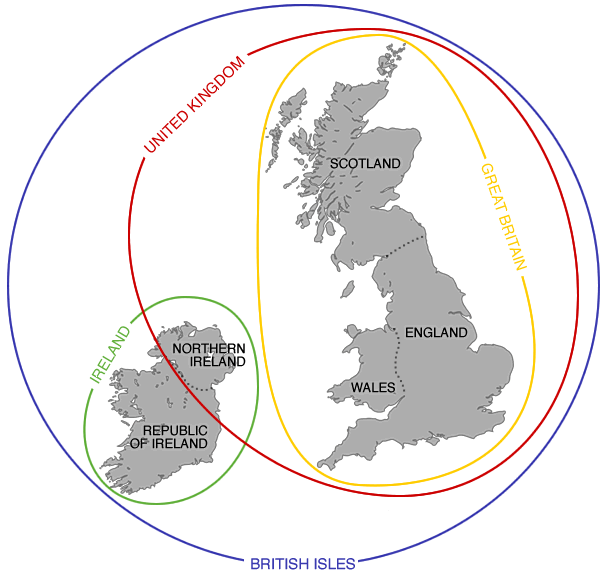
The map above demonstrates the difference between the British Isles, United Kingdom, Great Britain, and England. While the terms are often used interchangeably they actually mean different things.
The British Isles – While this is most common name for the archipelago, it is not used in the Republic of Ireland who instead refer to them as either the British-Irish Isles or simply as “these islands”.
Whatever name you choose, it consists of the islands of Great Britain, Ireland and over six thousand smaller isles (including: the Bailiwicks of Jersey and Guernsey and the Isle of Man). In total they cover an area of 315,159 km2 (121,684 sq mi) and collectively have a population of just over 67 million people.
Whatever name you choose, it consists of the islands of Great Britain, Ireland and over six thousand smaller isles (including: the Bailiwicks of Jersey and Guernsey and the Isle of Man). In total they cover an area of 315,159 km2 (121,684 sq mi) and collectively have a population of just over 67 million people.
Great Britain:
Great Britain is the larger of the the two main islands in the British Isles accounting for 73% of the land area (229,848 km² km2; 88,744 sq mi) and 90% of the population (60.8 million). It is divided into three countries all of whom are part of the United Kingdom (see below).
- England: the largest country in Great Britain accounting for 57% of the area (130,279 km2; 50,301 sq mi) and 86% of the population (53 million).
- Scotland: the 2nd largest country in Great Britain accounting for 34% of the area (77,933 km2; 30,090 sq mi) and 9% of the population (5.3 million).
- Wales: the smallest country in Great Britain accounting for 9% of the area (20,779 km2; 8,022 sq mi) and 5% of the population (3 million).
Ireland:
Ireland is the smaller of the two large islands in the archipelago, accounting for 27% of the land area (84,421 km2; 32,595 sq mi) but just under 10% of the total population (6.4 million). It is divided between the fully independent sovereign state of the Republic of Ireland and Northern Ireland which is one of the four countries of the United Kingdom (see below)
- Republic of Ireland: Accounts for 83% of the area of Ireland (70,273 km2; 27,133 sq mi) and 72% of the population (4.6 million).
- Northern Ireland: Accounts for only 17% of the area (14,130 km2; 5,456 sq mi) and 28% of the population (1.8 million) of the island of Ireland.
United Kingdom: The United Kingdom is a fully independent sovereign state made up of the the 3 countries on Great Britain plus Northern Ireland, which is reflected in its full name: United Kingdom of Great Britain and Northern Ireland.
This article was posted on Brilliant Maps and was called: England vs Great Britain vs United Kingdom Explained


