lordroel
Administrator
Posts: 67,964 
Likes: 49,369
|
Post by lordroel on Jun 25, 2019 18:52:47 GMT
Post here maps from the past. Lets start by posting this map from 1936 about the Battle of Jutland.  |
|
lordroel
Administrator
Posts: 67,964 
Likes: 49,369
|
Post by lordroel on Jun 26, 2019 15:12:06 GMT
A spectacular pictorial map designed to convey United States’ military might and preparedness, produced as war raged in Europe but prior to the Japanese attack on Pearl Harbor.  |
|
lordroel
Administrator
Posts: 67,964 
Likes: 49,369
|
Post by lordroel on Jun 28, 2019 12:25:13 GMT
Australia's War Map, 1942
|
|
lordroel
Administrator
Posts: 67,964 
Likes: 49,369
|
Post by lordroel on Jul 8, 2019 15:19:28 GMT
A nice map published in 1938 showing the entire United States Navy, 3 years before the Japanese attack on Pearl Harbor on December 7, 1941.  |
|
lordroel
Administrator
Posts: 67,964 
Likes: 49,369
|
Post by lordroel on Jul 17, 2020 18:29:05 GMT
Interesting map from Time magazine from June 21st 1943 about 4 routes leading to Berlin, only 1 of them would happen in real life. 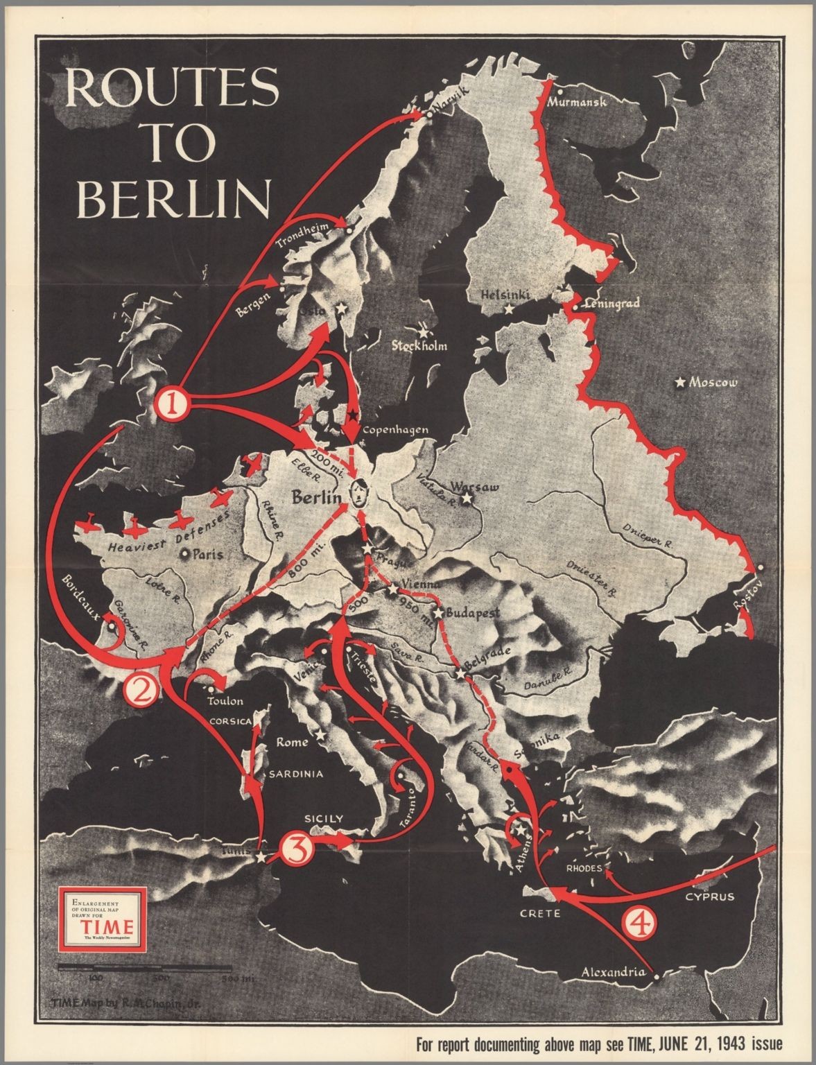 |
|
stevep
Fleet admiral
Posts: 24,832 
Likes: 13,222
|
Post by stevep on Jul 18, 2020 11:31:02 GMT
Interesting map from Time magazine from June 21st 1943 about 4 routes leading to Berlin, only 1 of them would happen in real life. 
Interesting that despite being a US publication it ignores the route that the US military and political leadership was set on from the point they were drawn into the war. They even marked N France as the region with the strongest defences.
Unless of course their higher levels were in on the secret and hence this was a deliberate attempt at misdirection, knowing that such an influential publication would draw at least some Nazi attention. The fact that they look at every other even vaguely possible route including the rather dubious one via Norway and Denmark could be over-egging things however. Although they do exclude also the idea of a landing in Iberia which I think at least Franco was concerned about.
Technically as well as route 3 part of route 2 was also used. No landing in the Bay of Biscay but there were landings in S France in the Med.
Steve
PS Just noticed one other point. The map limits Germany to not just its pre-war borders but also excludes not only Bohemia but also Austria.
|
|
lordroel
Administrator
Posts: 67,964 
Likes: 49,369
|
Post by lordroel on Jul 18, 2020 11:35:43 GMT
Interesting map from Time magazine from June 21st 1943 about 4 routes leading to Berlin, only 1 of them would happen in real life.  Interesting that despite being a US publication it ignores the route that the US military and political leadership was set on from the point they were drawn into the war. They even marked N France as the region with the strongest defences. Unless of course their higher levels were in on the secret and hence this was a deliberate attempt at misdirection, knowing that such an influential publication would draw at least some Nazi attention. The fact that they look at every other even vaguely possible route including the rather dubious one via Norway and Denmark could be over-egging things however. Although they do exclude also the idea of a landing in Iberia which I think at least Franco was concerned about.
Technically as well as route 3 part of route 2 was also used. No landing in the Bay of Biscay but there were landings in S France in the Med.
Steve
PS Just noticed one other point. The map limits Germany to not just its pre-war borders but also excludes not only Bohemia but also Austria.
I responded to a comment on Twitter when i posted this map: |
|
gillan1220
Fleet admiral
I've been depressed recently. Slow replies coming in the next few days.
Posts: 12,609 
Likes: 11,326
|
Post by gillan1220 on Jan 13, 2021 8:01:57 GMT
Philippines Campaign (1941-1942)Disposition of United States Army forces in the Philippines in December of 1941 Advance Japanese landings in the Philippines 8–20 December 1941 Advance Japanese landings in the Philippines 8–20 December 1941 A map of Luzon Island showing Japanese landings and advances from 8 December 1941 to 8 January 1942 A map of Luzon Island showing Japanese landings and advances from 8 December 1941 to 8 January 1942
|
|
Zyobot
Fleet admiral
Just a time-traveling robot stranded on Earth.
Posts: 17,352 
Likes: 7,260
|
Post by Zyobot on Jan 14, 2021 2:48:03 GMT
Apologies if this isn't quite what lordroel is looking for, but as long as we're posting maps from the past, how about I go further back for a change? 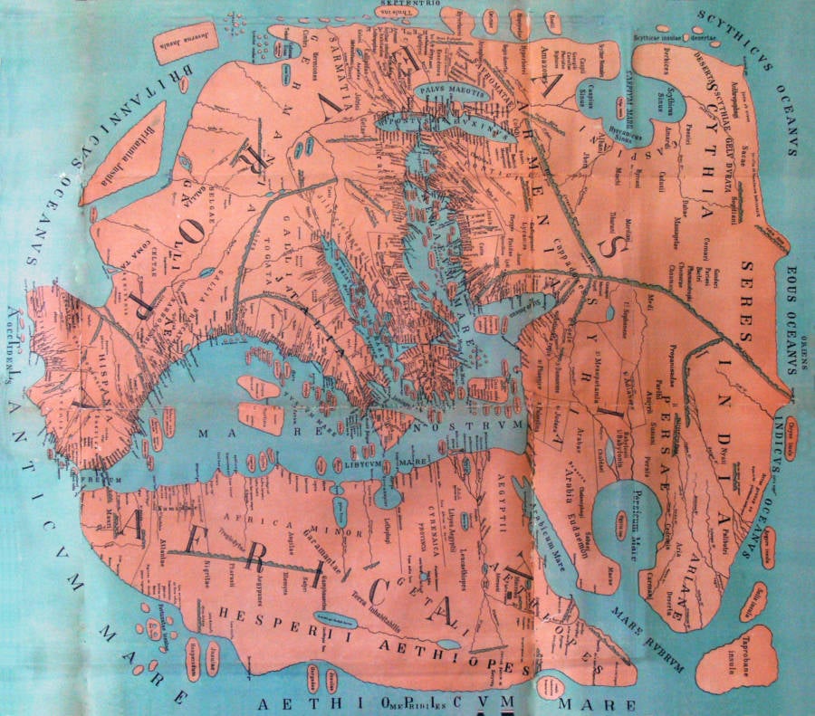 (This one's a map of the world created during Greco-Roman times. There's dozens more where that came from, for those interested.) |
|
gillan1220
Fleet admiral
I've been depressed recently. Slow replies coming in the next few days.
Posts: 12,609 
Likes: 11,326
|
Post by gillan1220 on Jan 14, 2021 3:11:32 GMT
|
|
gillan1220
Fleet admiral
I've been depressed recently. Slow replies coming in the next few days.
Posts: 12,609 
Likes: 11,326
|
Post by gillan1220 on Jan 22, 2021 6:19:11 GMT
Map of Cebu City, Las Islas Pilipinas, Spanish East Indies, c. 1873. (Source: Pinterest)  |
|
lordroel
Administrator
Posts: 67,964 
Likes: 49,369
|
Post by lordroel on Jan 23, 2021 21:51:46 GMT
Map of Cebu City, Las Islas Pilipinas, Spanish East Indies, c. 1873. (Source: Pinterest)  Would be nice to see one from 1973 to compare. |
|
gillan1220
Fleet admiral
I've been depressed recently. Slow replies coming in the next few days.
Posts: 12,609 
Likes: 11,326
|
Post by gillan1220 on Jan 24, 2021 4:28:40 GMT
Map of Cebu City, Las Islas Pilipinas, Spanish East Indies, c. 1873. (Source: Pinterest)  Would be nice to see one from 1973 to compare. The closest one I could find from the University of Texas - Austin Libraries. Cebu U.S. Dept. of State 1981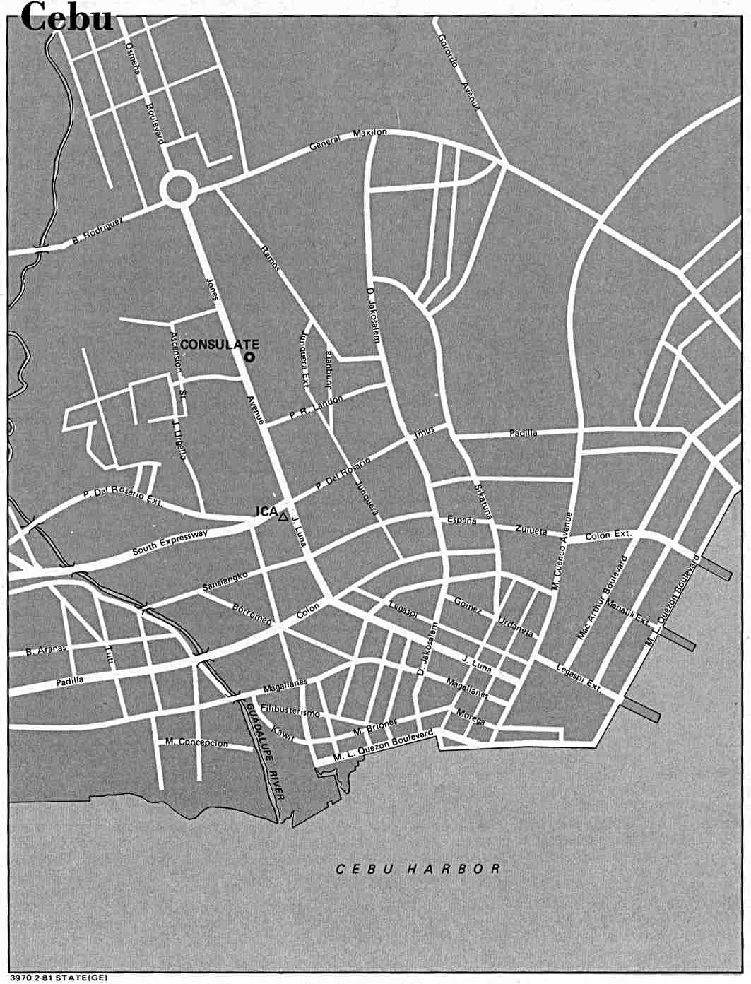 |
|
Zyobot
Fleet admiral
Just a time-traveling robot stranded on Earth.
Posts: 17,352 
Likes: 7,260
|
Post by Zyobot on Jan 28, 2021 23:21:42 GMT
Nice. I don't suppose you could recommend any places that I could find maps (and other attendant information that provides further context)? |
|
gillan1220
Fleet admiral
I've been depressed recently. Slow replies coming in the next few days.
Posts: 12,609 
Likes: 11,326
|
Post by gillan1220 on Jan 29, 2021 4:33:14 GMT
Nice. I don't suppose you could recommend any places that I could find maps (and other attendant information that provides further context)? That website I linked to has a lot of old maps. You can check it out. |
|


